
In the heart of the Arabian Peninsula, Oman stands as a beacon of digital ambition, rapidly reshaping its telecommunications landscape to meet the demands of a connected world, while leveraging innovative solutions for progress. Established in 2014, Oman Broadband Company has been at the forefront of this evolution, tasked with delivering high-speed, affordable internet to millions across the nation. With a goal to achieve 95 percent urban broadband coverage by 2030, the company is not merely expanding access but redefining how networks are managed through innovative Geographic Information System (GIS) technology. This transformation, driven by strategic partnerships and cutting-edge tools, addresses long-standing operational challenges while setting a new standard for efficiency and customer service. The journey of Oman Broadband offers a compelling glimpse into how technology can bridge infrastructural gaps, ensuring that even the most remote areas are woven into the digital fabric. This narrative of progress highlights both the hurdles overcome and the visionary steps taken to secure a robust telecom future for Oman.
Tackling Legacy Challenges with Modern Solutions
Oman Broadband’s mission to connect nearly a million premises has been a monumental task, marked by significant growth but also by daunting obstacles. By last year, with over 300,000 subscribers already linked to its network, the company faced mounting pressure as its outdated systems buckled under the weight of expansion. Manual processes bogged down operations, data processing delays hindered timely decision-making, and limited connectivity in the field created inefficiencies that threatened to derail national connectivity goals. These bottlenecks were not just technical issues but barriers to scalability, making it clear that a fundamental shift was needed to sustain growth. The urgency to modernize became evident as the demand for high-speed internet surged, pushing the company to seek innovative ways to manage its sprawling fiber-optic infrastructure with greater agility and precision.
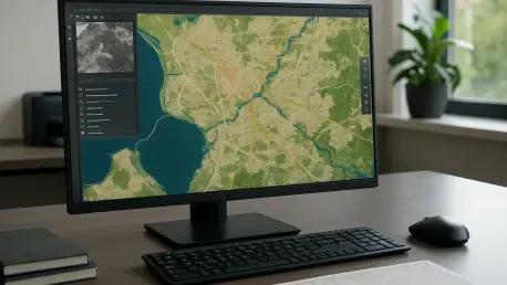
The turning point came through a strategic partnership with 3-GIS, an Esri partner, which introduced GIS-based solutions to overhaul Oman Broadband’s network management. This collaboration marked a departure from legacy systems, replacing cumbersome workflows with the 3-GIS | Web platform powered by ArcGIS Enterprise. Tools like fiber tracing and diagramming brought a new level of accuracy to network planning and maintenance, directly addressing the inefficiencies that once plagued operations. This technological leap was not merely about adopting new software but about reimagining how telecom infrastructure could be managed in a rapidly growing digital landscape. By integrating these advanced systems, Oman Broadband laid the groundwork for a more responsive and scalable network, capable of meeting both current demands and future challenges with confidence.
Revolutionizing Efficiency Through GIS Implementation
The adoption of GIS technology yielded transformative results for Oman Broadband, with efficiency gains that reshaped daily operations. Tasks that previously dragged on for days, such as data loading, were reduced to mere minutes—a staggering drop from 10 days to just eight. This dramatic improvement enabled the company to connect an impressive 400 new customers each day, a clear indicator of streamlined processes that could keep pace with rising demand. Such advancements were not just about speed but about creating a system where resources could be allocated more effectively, ensuring that no opportunity for connectivity was missed. The ripple effect of these changes touched every corner of the organization, proving that GIS was a catalyst for comprehensive operational reform.
Beyond individual task improvements, the broader impact of GIS was seen in the expansion of system access across the company. What was once limited to a mere 30 users grew to over 300, empowering engineers, contractors, and decision-makers with real-time access to critical network data. This democratization of information fostered collaboration, allowing teams to work in sync regardless of their location or role. Errors decreased as manual data handling was replaced by automated, GIS-driven processes, while the ability to make informed decisions on the fly became a cornerstone of operational success. This shift underscored how technology could break down silos within a telecom provider, creating a unified approach to network management that prioritized both efficiency and accuracy in equal measure.
Enhancing Field Operations with Mobile Innovation
Field operations, often the frontline of telecom service delivery, saw a significant boost through the deployment of 3-GIS | Mobile, a tool designed to bring GIS capabilities directly to on-site teams. Engineers and contractors gained the ability to access real-time data and perform fiber tracing right from the field, eliminating the delays that once stemmed from disconnected workflows. This mobile empowerment translated into faster service activations and repairs, directly impacting the quality of customer experiences across Oman. By equipping field staff with such tools, Oman Broadband ensured that even the most remote or complex network challenges could be addressed promptly, reinforcing its commitment to connectivity in every corner of the nation.
The significance of mobile GIS tools extends beyond immediate fixes to reshaping how field operations align with broader company goals. With instant updates and data synchronization, discrepancies between office plans and on-ground realities diminished, creating a seamless flow of information that enhanced project timelines. Customer expectations for quick turnarounds were met more consistently, as field teams could resolve issues without the back-and-forth that previously slowed progress. This integration of mobile technology highlighted a critical aspect of modern telecom management: the need for agility in the field is as vital as efficiency in the office. Oman Broadband’s investment in such innovations positioned it as a responsive provider, ready to adapt to the dynamic needs of a growing subscriber base.
Bridging Infrastructure and Customer Needs
One of the standout achievements of GIS adoption at Oman Broadband has been the integration of these systems with business support mechanisms to automate last-mile connectivity. This process, which spans from order placement to service activation, was once riddled with delays and manual errors, often leaving customers frustrated. Now, with GIS-driven automation, the journey from request to connection is smoother and faster, ensuring that subscribers experience minimal wait times. This focus on the last mile reflects a deeper understanding of how technical infrastructure must ultimately serve human needs, making technology a bridge between complex networks and the end user’s expectations for reliable internet access.
This customer-centric approach, enabled by GIS, also allows Oman Broadband to anticipate and address service issues before they escalate. By mapping network layouts with precision and linking them to customer data, the company can pinpoint potential bottlenecks or failure points in the delivery chain. Such proactive measures not only reduce downtime but also build trust with subscribers who rely on consistent connectivity for work, education, and daily life. The strategic use of GIS as a tool for enhancing service delivery illustrates a broader trend in telecom: technology must go beyond internal efficiencies to create tangible value for the people it serves. Oman Broadband’s success in this area sets a compelling example for how digital tools can transform the customer experience.
Pioneering a Sustainable Digital Future
As Oman Broadband looks to the years ahead, GIS technology is being positioned as the backbone of a future-ready telecom network. Plans are underway to leverage these systems for predictive maintenance, allowing the company to foresee network issues before they disrupt service. This forward-thinking strategy aims to minimize downtime and optimize resource allocation, ensuring that the infrastructure remains robust even as demand continues to grow. With national targets like 95 percent urban broadband coverage by 2030 in sight, such innovations are crucial for maintaining momentum and delivering on promises of universal digital access across Oman.
Equally important is the role of GIS in enhancing long-term scalability and customer satisfaction. By using data-driven insights to refine network planning and expansion, Oman Broadband can strategically target underserved areas while balancing operational costs. This approach not only supports national digital goals but also positions the company as a regional leader in telecom innovation. The commitment to harnessing GIS for continuous improvement reflects a vision that extends beyond immediate gains, focusing instead on building a resilient infrastructure that can adapt to evolving technological and societal needs. Oman’s telecom sector, through these efforts, is crafting a blueprint for sustainable digital progress that others may follow.